
Pam’s Pictorama Post: I bought this clutch of postcards for a few dollars at the recent postcard extravaganza. They all depict the early days of the shore area where I grew up and now have my mom’s house. Like most areas it has largely been built up and built over, but some of the buildings remain or did during my childhood. All of these postcards appear to be from approximately the same period. Only the one from Rumson at the bottom was mailed and that is dated 1910.
If I had my way we would have spent a lot more time in Asbury Park when I was a kid. It was on hard times in the ’60’s and early 70’s and generally we migrated to things north of us rather than south of us in Monmouth County. This pier, as above, remained and even back then I was fascinated by it. It was somewhat derelict although still in use. There was a carousel in another building that I never got to ride. To my knowledge that remains – it was used in the recent Bruce Springsteen bio pic (which for a Jersey girl like myself was a wonderful compendium of places I grew up hanging out at) so I assume it is in reasonable repair.
The boardwalk is in all its glory here with women in long white cotton dresses of a turn of the century or early ‘teens summer. Parasols and hats abound. The amusements are largely hidden although there is a place for your photo to be taken and where film is sold. (Sadly absolutely no evidence that you could have your photo taken with a giant Felix doll. It just doesn’t seem to have been a thing in the US.)
The North End Hotel is the large building in front of us and below it is identified as Boardwalk and North End Hotel. Asbury Park, N.J. North End Hotel or not, I’m pretty sure the lower pier is what goes out toward the water, the boardwalk above and the sand leading to the water to our right below. I assume some of the long building was bath house space where you could rent a locker for the day, change and leave your things. Although the pier in Long Branch existed into my young adulthood (it was eventually consumed by a fire), it is the only one of the long piers into the water I remember – although maybe Asbury did or does still have one. I am scheming to get there for an ephemera sale this summer if possible and to spend the day checking it out.
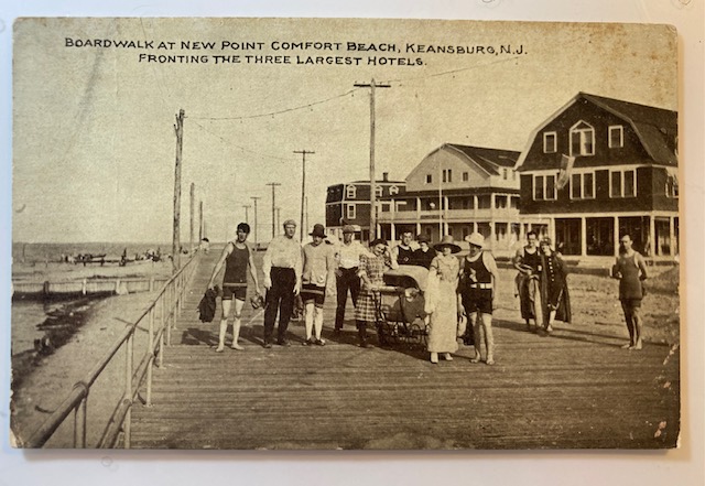
Keansburg was north of us, however I was (sadly) never taken to the beachside amusement pier there. It too still exists in some form. (There used to be ads for it on local television – Keansburg Amusement Park.) I don’t think any of these beachside hotels still exist however. To my knowledge only the tinier waterside homes still stand in that area. I have to admit I have never been on their boardwalk, although I spent much time in neighboring Highlands and even Matawan where my sister lived for several years.
This is what the towns of Long Branch and Sea Bright would have also looked like, the shore dotted with large hotels and rooming houses on the water which largely no longer exist. The trip down Ocean Avenue between Sea Bright and Monmouth Beach and then to Long Branch is still lined with some of the old single-family mansions overlooking the ocean and somehow surviving both tides and progress, mixed with new construction and the occasional beach club.
Until just a few years ago, the highway referred to in this photo of a swath of Atlantic Highlands would have been the very same one which people routinely walked over in order to go to and from Sandy Hook state park and connecting to Sea Bright. A new much higher and larger highway was installed to much construction mess, expense and fanfare. I guess you can still walk (and bike) across the new one, but it is vastly larger for more cars and most importantly, more boats below it. (It is no longer a drawbridge.)
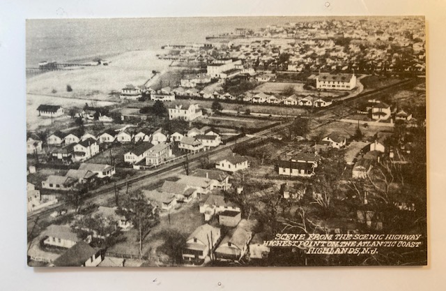
While likely more crammed and with contemporary stores and some more modern homes, my guess is that this view has remained somewhat the same with small cottages dotting the shore. This would have the Shrewsbury River just in view to the left with the bay to the ocean (and New York City in the distance) behind the viewer. The ocean is just on the other side of the tiny spit of land that is Sandy Hook and Sea Bright and the photographer, standing on the highway, could easily have seen all these things by turning around.
There was a time when this was a major stop on passenger pleasure cruises heading south and I assume for day trippers, even as it is by ferry in the summer today. (I could take the ferry today but beach traffic will snare on the weekend so instead I will take the train which will leave me closer to the house.) One of my ancient novels had a stop there on a cruise which I enjoyed finding immensely.
Finally, I get to my hometown of Rumson. There was a time when I knew the length of Rumson Road like the back of my hand from years of being a passenger traveling up and down it. A major artery running not just through the town but connecting the beach communities with the rest of the area, it is fairly long and famously heavily trafficked. (The Sea Bright bridge at one end was also a drawbridge and traffic during the summer would back up for miles for boat traffic. That bridge has also been replaced recently, leaving only the Rumson bridge in a state of sad decay and planned replacement.) Having said that I am puzzled by this view. While small water tributaries create a number of manmade and natural ponds and streams throughout the area, I am stumped by one of this size. (I wrote about a photo of a small pond near my house in the town of Fair Haven here.)

I am wondering if this was ultimately filled in to make the golf course or country club. I will ask some of the folks who have lived there longer than I have. For all of that I like this card because it captures the feel of Rumson and Rumson Road. In the fall it is the most beautiful drive lined with old trees, leaves turned. It has always been a sort of millionaires’ row of mansions, old and new, despite being a few blocks in from the river which you would think would be more prime real estate. Perhaps the flooding discouraged the largest homes perching there and I grew up on an inlet of the river, a block off this road. If I calculate correctly though I lived much further east, where Rumson Road begins at the Sea Bright bridge. This would be on the western part as you head into the town of Little Silver, my current home in Fair Haven where these three towns connect.
As noted above, this card was mailed. On the back it says (in one run-on sentence), suppose you have been after chestnuts before this wish I was there to go along Harold. It was mailed to Miss Mary Crawford, Pine Bush, Orange Co, NY. It was mailed from Sea Bright, NJ on October 13, 1910. (Until a few years ago the post office in Sea Bright would have been this one. Sadly a larger and more modern building replaced it too.)
As I head out today I am tucking these in my bag to take with me. I will round up some frames for them and put them up at the house where both local images, beaches and piers in general and wider New Jersey images rule. (Some of those posts can be seen here and here – I have a passion for panorama photos but they are hard to document!) Keep an eye on Instagram for some garden pics. My project for the weekend is to acquire and plant some tomatoes.
